Dir and Kumrat Valley Travel Guide: Pine Forests, Meadows and Katora Lake

Pakistan Locals Team
9 August 2026 · 4 min read
At a glance
- Location
- Dir and Kumrat Valley
- Region
- Khyber Pakhtunkhwa
- Best time
- June to September, when the road is open and the meadows are green. The valley is snowbound in winter
- Duration
- 3 to 4 days
- Altitude
- Around 2,000 m in Kumrat, about 3,000 m at Jahaz Banda, and roughly 3,700 m at Katora Lake
While the crowds pour into Hunza and Swat, the valleys of Dir stay gloriously quiet. This is the far northwest of Khyber Pakhtunkhwa, up against the Afghan border, and its crown jewel is Kumrat, a valley of towering deodar pines, tumbling waterfalls and the clear Panjkora River, with the alpine meadow of Jahaz Banda and the hidden Katora Lake above it. The road in is long, but that is exactly what has kept it unspoilt. Here is how to do it.
How to get there
Getting to Kumrat is half the commitment. From Islamabad you take the Swat Motorway to Chakdara, then the N-45 highway north through Timergara and the town of Dir to Thal, the last town a normal car can reach. That is roughly 370 to 385 km and a full 8 to 9 hours of driving, usually broken with a night in Dir or Thal. From Thal, you leave the tarmac and take a jeep the rest of the way into Kumrat, and higher again to Jahaz Banda. It is a long haul, so give yourself the time to enjoy it rather than racing up and back.
Kumrat Valley
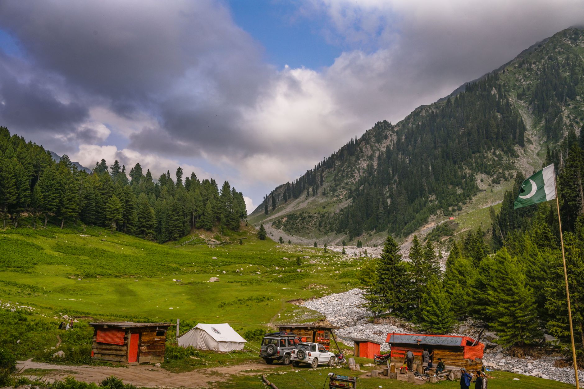
Kumrat itself runs about 35 km along the Panjkora River, and it is unlike the bare high valleys further north. Here the mountainsides are thick with deodar and pine forest, the air smells of resin, and the river crashes white over boulders. The valley is dotted with waterfalls, the biggest of which, the Kumrat Waterfall, is a short walk from the main camping grounds. Most people simply camp among the pines for a night or two, and that is the whole joy of it.
Jahaz Banda and Katora Lake
The reason trekkers come is above the valley. A rough jeep track from Thal climbs to Jahaz Banda, a wide green meadow at around 3,000 m scattered with stone huts, which serves as the base camp. From there, a moderate trek of three to four hours over rocky trails leads to Katora Lake, a perfect bowl of turquoise water cupped in the mountains at roughly 3,700 m. It is one of the loveliest alpine lakes in the country, and far quieter than the famous ones. We have a full Kumrat and Katora Lake trek guide with the day-by-day detail.
Kala Chashma and the springs
Lower in the valley, Kala Chashma is a famous cold spring where icy mountain water bubbles up beside the pines, a classic Kumrat picnic and photo stop. There is a second spring further on, Do Kala Chashma, for those with more time. They are a lovely, easy contrast to the higher treks.
Thal, Sheringal and Lower Dir
The gateway towns are worth knowing. Thal is your last stop for supplies and fuel and where you switch to a jeep. On the drive up you pass through Sheringal, a green university town, and the district hub of Dir. Down in Lower Dir, Timergara and Chakdara are the gateways, and Chakdara has a small museum and Gandhara-era remains if you want a stop on the way.
When to go
Kumrat has a short season. Come between June and September, when the snow has cleared, the jeep track is open, the meadows are green and Katora Lake has thawed. July and August are the busiest and greenest. From October the cold sets in, and through winter the upper valley is buried in snow and effectively closed.
Permits and safety
Upper Dir and Kumrat are settled, open districts and need no permit or NOC, though you should carry your CNIC or passport for the checkposts along the N-45. The main things to respect are the long, winding road, the rough jeep tracks, which should be driven by day with an experienced local driver, and the altitude on the Katora trek. Come prepared and it is a straightforward, deeply rewarding trip.
Where to stay and what to pack
Kumrat is a camping destination first and foremost, with a growing number of wooden huts and tented camps among the pines, most running on limited solar power. Thal has basic hotels, and Jahaz Banda has simple stone guesthouses and camping for the Katora trek. Bring warm layers and a good sleeping bag even in summer, a rain shell, sturdy shoes, a power bank and plenty of cash, because there are no ATMs and little signal beyond Dir.
Quick answers
How long is the drive from Islamabad? About 8 to 9 hours to Thal, then a jeep into Kumrat.
Best time to visit? June to September. The valley is snowbound in winter.
Do you need a permit? No, Upper Dir and Kumrat are open districts.
How hard is the Katora Lake trek? Moderate, three to four hours each way from Jahaz Banda, at altitude.
Written and fact-checked by the Pakistan Locals editorial team, with local hosts and drivers in Dir. Last updated August 2026. Road and track conditions change with the season, so check locally before you set off.
Sources and further reading
Plan the trip with local hosts and jeep drivers on Pakistan Locals, or host travellers in Dir. Next, read our Kumrat and Katora Lake trek guide and the Swat and Kalam guide for the valley next door.
Questions people ask
How do you get to Kumrat Valley?+
Drive from Islamabad via the Swat Motorway to Chakdara, then the N-45 through Timergara and Dir to Thal, roughly 8 to 9 hours. From Thal you switch to a jeep for Kumrat and Jahaz Banda.
When is the best time to visit Kumrat and Katora Lake?+
June to September. The road opens once the snow clears, the meadows are green, and Katora Lake is thawed. Winter locks the whole valley under snow.
Do you need a permit for Dir or Kumrat?+
No. Upper Dir and Kumrat are settled districts open to travellers, with no NOC required. Carry your CNIC or passport for checkposts.
How hard is the Katora Lake trek?+
From Jahaz Banda meadow it is a moderate trek of about three to four hours each way over rocky trails to the lake at roughly 3,700 m. A local guide or porter is recommended.
Pakistan Locals Team
The Pakistan Locals editorial team writes practical, on-the-ground travel guides to Pakistan, researched and fact-checked in consultation with our network of local hosts and guides.